Datei:Regionale MS trends NH.jpg
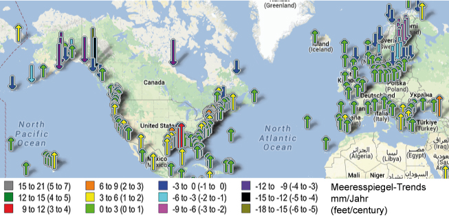
Regionale_MS_trends_NH.jpg (653 × 317 Pixel, Dateigröße: 201 KB, MIME-Typ: image/jpeg)
Das Nildelta im Norden von Ägypten; rechts der Suez-Kanal.
Lizenzhinweis
|
Dieses Bild basiert auf dem Bild: NOAA Tides & Currents: Sea Level Trends This image is in the public domain because it contains materials that originally came from the U.S. National Oceanic and Atmospheric Administration, taken or made as part of an employee's official duties. |
Dateiversionen
Klicken Sie auf einen Zeitpunkt, um diese Version zu laden.
| Version vom | Vorschaubild | Maße | Benutzer | Kommentar | |
|---|---|---|---|---|---|
| aktuell | 22:29, 2. Feb. 2014 | | 653 × 317 (201 KB) | Dieter Kasang (Diskussion | Beiträge) | Das Nildelta im Norden von Ägypten; rechts der Suez-Kanal. ==Lizenzhinweis== {| style="border:1px solid #8888aa; background-color:#f7f8ff;padding:5px;font-size:95%;" | Dieses Bild basiert auf dem Bild: NOAA Tides & Currents: [http://tidesandcurrents.… |
Sie können diese Datei nicht überschreiben.
Dateiverwendung
Die folgende Seite verwendet diese Datei: