Nicht kategorisierte Dateien
Aus Klimawandel
Unten werden bis zu 100 Ergebnisse im Bereich 51 bis 150 angezeigt.
-
 Aerosole-SSP-emissionen-antrieb.jpg 999 × 337; 126 KB
-
 Aerosole-Wolken-Strahlung.jpg 716 × 435; 197 KB
-
 Aerosole-temp-2050.jpg 931 × 473; 157 KB
-
 Aerosole Ostchina.jpg 674 × 661; 70 KB
-
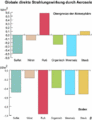
 Aerosole Strahlungseffekt.jpg 755 × 437; 88 KB
-
 Aerosole china.gif 498 × 407; 15 KB
-
 Aerosole dimming.gif 447 × 318; 9 KB
-
 Aerosole entstehung.gif 669 × 403; 31 KB
-
 Aerosole lebensdauer.gif 488 × 505; 17 KB
-
 Aerosole prozesse.gif 652 × 397; 29 KB
-
 Aerosole russquellen.gif 747 × 370; 22 KB
-
 Aerosole staubquellen.gif 794 × 425; 23 KB
-
 Aerosole temp zonal.gif 456 × 399; 12 KB
-
 Aerosole temperatur geogr.jpg 599 × 292; 132 KB
-
 Aerosolkonzentration2006 Europa.jpg 573 × 490; 276 KB
-
 Aerosols-GHG-prec.jpg 1.022 × 270; 214 KB
-
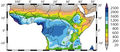
 Aerosols SST Sahel-rain.jpg 884 × 685; 146 KB
-
 Aerosolszenarien.jpg 575 × 383; 102 KB
-
 Aerosolwirkung-direkt.gif 658 × 465; 25 KB
-
 Aerosolwirkung-indirekt.jpg 842 × 595; 229 KB
-
 Aerosolwirkung oben unten.gif 412 × 536; 14 KB
-
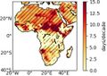
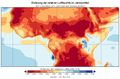
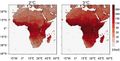 Africa-hot-nights.jpg 1.462 × 748; 863 KB
-
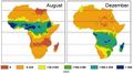 Africa-prec-aug-dec.jpg 826 × 464; 157 KB
-
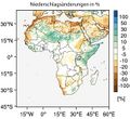 Africa-rainfall-change.jpg 583 × 532; 216 KB
-
 Africa aboveground biomass.jpg 1.041 × 1.041; 99 KB
-
 Africa biome type.jpg 893 × 988; 117 KB
-
 Africa land cover2002-2017.jpg 1.017 × 718; 98 KB
-
 Africa land degradation.jpg 720 × 813; 70 KB
-
 Africa summer days 1980-2018.jpg 1.039 × 736; 88 KB
-
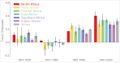 Africa temp trends.jpg 1.184 × 626; 51 KB
-
 Afrika 2100 A1B.jpg 452 × 596; 82 KB
-
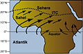
 Afrika ITC feucht.jpg 672 × 297; 81 KB
-
 Afrika ITC trocken.jpg 672 × 296; 80 KB
-
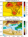
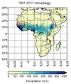 Afrika JJA-Niederschlag2001-2011.jpg 467 × 549; 58 KB
-
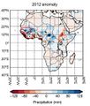 Afrika JJA-Niederschlag 2012.jpg 473 × 556; 57 KB
-
 Afrika Malariagebiet Niederschl.jpg 588 × 255; 107 KB
-
 Afrika Malariagebiet Temp.jpg 568 × 261; 136 KB
-
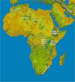
 Afrika Malariaverbreitung.jpg 483 × 291; 128 KB
-
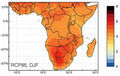 Afrika RCP85 Temp.jpg 410 × 260; 74 KB
-
 Afrika Relative Feuchte Jahr rcp85 dffII.jpg 880 × 576; 248 KB
-
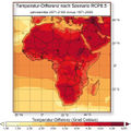 Afrika Temp diff2 RCP8.5.jpg 549 × 548; 180 KB
-
 Afrika Topographie.jpg 656 × 718; 380 KB
-
 Afrika agrarproduktion2080.jpg 205 × 270; 46 KB
-
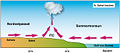
 Afrika monsun.jpg 373 × 244; 60 KB
-
 Afrika sommermonsun.jpg 373 × 244; 37 KB
-
 Afrika temp diff2 RCP4.5 8.5.jpg 840 × 544; 314 KB
-
 Agrarland 2007.jpg 2.128 × 1.046; 445 KB
-
 Agrarlandschaft-Eiderstedt.jpg 800 × 443; 95 KB
-
 Agrarproduktion2080.jpg 550 × 355; 70 KB
-
 Agroforestry Burkina Faso.jpg 1.040 × 788; 262 KB
-
 Agroforestry crop residue.jpg 953 × 803; 195 KB
-
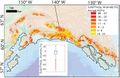
 Alaska ELA increase glaciers.jpg 1.032 × 669; 118 KB
-
 Alaska Mountains.jpg 519 × 471; 316 KB
-
 Alaska glaciers2012-2016.jpg 848 × 508; 97 KB
-
 Alaska glaciers NASA.jpg 828 × 621; 130 KB
-
 Alaska greening browning.jpg 1.020 × 384; 87 KB
-
 Alaska precRCP6.0 glaciers.jpg 1.025 × 657; 118 KB
-
 Alaska snowRCP6.0 glaciers.jpg 742 × 481; 261 KB
-
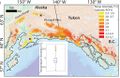 Alaska temp glaciers regions.jpg 1.023 × 667; 130 KB
-
 Albedo-Eis.jpg 761 × 579; 96 KB
-
 Albedo-Eis2.jpg 771 × 574; 97 KB
-
 Albedo-Werte.gif 1.622 × 2.324; 79 KB
-
 Albedo CO2 60Mio.jpg 447 × 322; 76 KB
-
 Albedo change.jpg 720 × 725; 162 KB
-
 Albedo erde.jpg 540 × 314; 105 KB
-
 Albedo sm.jpg 940 × 564; 47 KB
-
 Aletsch RCP2.6 8.5 2100.jpg 854 × 319; 48 KB
-
 Aletschgletscher.jpg 800 × 600; 142 KB
-
 Aletschgletscher 4.9.1902.jpg 640 × 509; 55 KB
-
 Algenblüte Tag 26 EIFEX.jpg 600 × 475; 0 Bytes
-
 Alpacas peru.jpg 920 × 690; 203 KB
-
 Alpen Lage Höhe.jpg 834 × 479; 100 KB
-
 Alpen Temperatur1770-2003.jpg 468 × 277; 61 KB
-
 AlpineHoehenstufen.jpg 672 × 381; 139 KB
-
 Alps-temp-2100-RCP.jpg 729 × 549; 274 KB
-
 Alps glacial lake Obersulzbach valley.jpg 729 × 485; 78 KB
-
 Alps glacier glacial cycle.jpg 1.063 × 713; 203 KB
-
 Alps glaciers1000-2000.jpg 738 × 782; 101 KB
-
 Alps glaciers1900-2100.jpg 564 × 437; 73 KB
-
 Alps glaciers area change.jpg 1.100 × 380; 82 KB
-
 Alps glaciers elevation change.jpg 1.100 × 394; 92 KB
-
 Alps glaciers length1000-2000.jpg 904 × 358; 48 KB
-
 Alps glaciers mass change.jpg 1.100 × 382; 94 KB
-
 Alps glaciers vol2100 RCP2.6 8.5.jpg 650 × 730; 120 KB
-
 Alps glaciers volume change.jpg 1.769 × 635; 200 KB
-
 Alps regions.jpg 664 × 377; 31 KB
-
 Alps snow mass 2100 RCPs.jpg 1.013 × 296; 56 KB
-
 Alps temp year summer2100.jpg 877 × 351; 65 KB
-
 Alps vol area change2100.jpg 451 × 607; 50 KB
-
 Altiplano.JPG 3.486 × 2.358; 180 KB
-
 Altiplano bolivien.JPG 3.456 × 2.592; 218 KB
-
 Amazon PDSI 1983-1998-2016.jpg 846 × 292; 63 KB
-
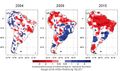
 Amazon drought 2005.jpg 350 × 353; 41 KB
-
 Amazon drought fire.jpg 446 × 539; 143 KB
-
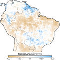
 Amazonas-Dürren2004-2009-2015.jpg 701 × 413; 177 KB
-
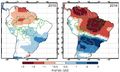 Amazonas Bodenfeuchte 2010 2016.jpg 771 × 461; 234 KB
-
 Amazonas Brandrodung.jpg 350 × 263; 27 KB
-
 Amazonas Dürre Baum.jpg 640 × 480; 95 KB
-
 Amazonas Feuer 24-26.8.19.jpg 585 × 621; 101 KB
-
 Amazonas Sekundärwald Feuer.jpg 402 × 679; 82 KB


