Nicht kategorisierte Dateien
Aus Klimawandel
Unten werden bis zu 50 Ergebnisse im Bereich 2.501 bis 2.550 angezeigt.
-
 SST global 1955-2024.jpg 719 × 541; 61 KB
-
 SST global 1961 1990 Jahresmittel.jpg 880 × 576; 280 KB
-
 SST global 1961 1990 Sommer.jpg 880 × 576; 284 KB
-
 SST global 1993-2015.jpg 710 × 395; 78 KB
-
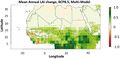
 SST global 2070 2099 RCP8.5 Jahresmittel.jpg 880 × 576; 278 KB
-
 SST global 2070 2099 RCP8.5 Somm.jpg 880 × 576; 291 KB
-
 SST global Diff2 RCP8.5 Jahr.jpg 880 × 576; 329 KB
-
 SST mediterranean 1993-2015.jpg 712 × 402; 105 KB
-
 SW-China drought frequency1961-2012.jpg 699 × 727; 93 KB
-
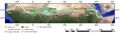
 SW-EU hydro temp1979-2023.jpg 1.110 × 773; 146 KB
-
 SW-EU prec 1951-2017.jpg 840 × 383; 36 KB
-
 SW-EU precipitation1979-2023.jpg 540 × 301; 31 KB
-
 SW-EU soil-moist1979-2017.jpg 840 × 383; 30 KB
-
 SW-EU temperature 1951-2017.jpg 840 × 383; 33 KB
-
 Saffir-Simpson1-6.jpg 720 × 89; 21 KB
-
 Sahel-Dürre-Aerosole.jpg 923 × 509; 211 KB
-
 Sahel-LAI-change-2100-RCP8.5.jpg 940 × 459; 197 KB
-
 Sahel-LAI-prec-1982-2016.jpg 1.610 × 528; 298 KB
-
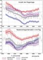 Sahel-Regentage--intensität1955-2010.jpg 567 × 791; 255 KB
-
 Sahel-prec-1982-2016.jpg 808 × 520; 154 KB
-
 Sahel Bäume.jpg 1.200 × 800; 178 KB
-
 Sahel Great Green Wall.jpg 1.800 × 515; 163 KB
-
 Sahel Strömungssysteme.jpg 736 × 543; 42 KB
-
 Sahel Tagesniederschlag2100.jpg 563 × 433; 46 KB
-
 Sahel Wind Winter Sommer-c.jpg 584 × 674; 186 KB
-
 Sahel Wind Winter Sommer.jpg 584 × 674; 192 KB
-
 Sahel index.gif 457 × 199; 12 KB
-
 Sahel ozean.gif 488 × 357; 48 KB
-
 Sahel prec 21st.jpg 772 × 514; 65 KB
-
 Sahel prec West-Central 2100.jpg 754 × 586; 87 KB
-
 Sahel precipitation.jpg 506 × 323; 87 KB
-
 Sahel prognose.gif 553 × 313; 47 KB
-
 Sahel rainfall 1900-2019.png 1.024 × 439; 20 KB
-
 Sahel rainfall timeseries.png 800 × 333; 8 KB
-
 Sahel seasonality.jpg 540 × 298; 51 KB
-
 Sahel temp niederschlag2100.jpg 666 × 355; 35 KB
-
 Sahelprecip1950-2012.jpg 601 × 344; 67 KB
-
 Salinity effect on rice.jpg 779 × 542; 90 KB
-
 Salzgehalt Mai 2016.jpg 1.063 × 471; 67 KB
-
 Salzgehalt Ozean.jpg 572 × 412; 87 KB
-
 Salzgehalt jahresmittel.jpg 640 × 454; 313 KB
-
 San Quintin glacier.jpg 720 × 480; 228 KB
-
 San rafael glacier.jpg 720 × 480; 190 KB
-
 Sandmücke.jpg 800 × 543; 50 KB
-
 Sandy Zugbahn Niederschlag.jpg 494 × 492; 255 KB
-
 Sandy goe 2012302 1745 front.jpg 719 × 480; 117 KB
-
 Sandy high water.jpg 608 × 607; 54 KB
-
 Satellit Blüte.jpg 3.367 × 2.356; 2,48 MB
-
 Satellite Andes.jpg 800 × 599; 70 KB
-
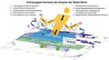
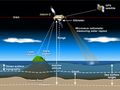 Satellite altimetry measurement.jpg 904 × 680; 55 KB


